Text by Peter Goodwin and Robin A.S. Haynes
With images from the Patten Free Library

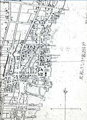
SEE NOTE Detail of USGS Topographical Map of Bath, 2000
Patten Free Library
Introduction
Downtown Bath, the heart of the City of Ships, encompasses only a small portion (less than one-half square mile), of the City’s total area of more than 9 square miles. The north-south length of the downtown is easily traversed in a 15-minute walk southward along Front Street from the Patten Free Library to the Customs House, just a block south of the T intersection of Front and Centre Streets. That distance, broken up into six irregular city blocks, is lengthy in comparison to the three-block, east-west width of this historic downtown. Packed into this small downtown area is a wealth of architectural, economic and family history revealed in part by the stories connected to the sites on this website.
The downtown of Bath evolved as a function of many local, national and international factors. Foremost among them is the city’s location on the west side of a navigable, straight, 5-mile stretch of the Kennebec River, a site that has proven to be ideal for shipbuilding for more than 200 years. Whether as a means of transporting of lumber for building ships in the 18th and 19th centuries, as a conduit for national and international commerce, as a watery road to the interior, or even as a barrier to land transportation, the Kennebec River played a central role in shaping the city and its downtown.
The geologic factors that physically shaped this stretch of the Kennebec River and the system of river-parallel ridges on which the city is situated include crustal plate movements, river erosion and continental glaciation. After the north-south oriented bedrock underlying the parallel ridges and valleys was formed and re-formed by plate movements hundreds of millions of years ago, erosion by rivers and continental ice sheets produced topography of ridges underlain by resistant bedrock such as granite, and valleys where the bedrock was more easily eroded. Here in Bath, the collective result of these processes is a deep, straight, five-mile shoreline ideally shaped for shipbuilding and easily reached by ocean-going ships.

Front Street, Bath, ca. 1903
Patten Free Library
The cultural factors laid over this geologic footprint determined how this site was used and how the downtown area evolved in response to those various uses. European settlement of North America in the 17th and 18th centuries, social and economic development, and the resulting international trade in fish, furs and lumber led to the boom period of 19th-century wooden shipbuilding. Wars, national economic upswings and downturns, changes in modes of transportation, cultural trends, as well as city-wide fires provided both positive and negative growth stimuli. The resulting array of downtown buildings is an amazingly complete and attractive record of Bath’s history.
Early Settlement
While members of the Abenaki lived seasonally in the area of Bath, no permanent Native American villages occupied the site. And, no settlements resulted from early European explorations of the area until the Popham Colony was started at the mouth of the Kennebec in 1607. Though short-lived, that British colony marked the beginning of more permanent settlement along the western side of the river in what became known as the town of Kennebec. Among the earliest of those settlers was Robert Gutch who purchased much of the area now known as Bath from various Native Americans.
This pattern of Colonial settlement, including the process of purchasing parcels from the Gutch Estate, establishing homes and businesses, and creating local governments, was disrupted in the third quarter of the seventeenth century by a series of conflicts with Native Americans. The turmoil culminated in this region in 1676 with raids on both the Hammond Trading Post at the Narrows across from Chops Point on the eastern shore of the Kennebec and the Clarke and Lake Post in Arrowsic. Although some colonists persevered in the coming years, additional wars and attacks temporarily stalled settlement efforts along the Kennebec.
As settlement resumed in down-river areas, Arrowsic Island was incorporated as the Town of Georgetown in 1716. In 1738 Georgetown was enlarged by the addition of Parkers Island (the current Georgetown), Phippsburg, Woolwich and the area now known as Bath and West Bath. Bath, then called Long Reach, first achieved a separate identity as the Second Parish of Georgetown in 1759. Approximately eight structures or portions of buildings in the current city limits, mostly residences outside the downtown area, stand as testaments of that period from the mid-eighteenth century to the time of the town’s incorporation as Bath in 1781.
Downtown from 1759 to 1815
The center of shipbuilding activity and settlement in the latter half of the 18th century was in what is now known as the South End of Bath. In the early 1760s, William Swanton arrived in Long Reach and built his yard and the first wharf in town at the foot of Federal Street, an area now covered by Bath Iron Works (BIW), north of Russell Street. In the early 1780s, the second wharf in town was built at the foot of South Street. Its owner, Jonathan Davis, also constructed a store that was joined in the next decade by others. Not surprisingly, the street was known initially as Davis’s Lane and became the first central business district of the community. By 1800, Bath’s population was 1225, testimony to remarkable growth from the early days of the Second Parish when approximately forty families occupied the Bath-West Bath area.

Early in the 19th century, the center of town moved northward to its present location, a move that had begun when Joshua Shaw purchased “The Point” and divided it into lots for sale. This peninsula of slightly higher land, where much of today’s downtown sits, was approachable from the southwest through a narrow neck in the vicinity of Vine Street. Shaw appears to have offered more reasonably priced parcels than were available in the South End, thereby diverting development and rewriting the face of the city. Nevertheless, the coves, creeks, and tidal flats that surrounded the Point created a problematic landscape where several bridges were needed to extend Centre Street, to create Front Street, to connect Elm Street, and to traverse the waters of Water Street. Throughout the nineteenth century, as the lowest of these areas were filled in and Commercial Street was added to the east of Front Street, the landscape of the downtown expanded toward the river and began to resemble that of the present day.

By 1800, shipyards built ships for local owners heavily involved in national and international trade, principally with the West Indies, France and Great Britain. Among the prominent entrepreneurs of this time was newcomer William King, who built a home on Shaw’s Point and later the Bath Bank building, the first brick structure on the Point, on the southwest corner of the intersection of Front and Centre Streets. After his death in 1852, King’s home was moved to Vine Street to make way for building the Customs House. In addition to being a successful businessman and prominent social figure, King was Bath’s representative in the Massachusetts legislature and later Maine’s foremost proponent of statehood, eventually chairing the constitutional convention in 1819 and becoming the State’s first governor in 1820 (see King exhibit at www.mainememory.net.)
Boom Times for the City of Ships (1815-1860)
Following the War of 1812, Bath and the rest of the country experienced a lengthy period of expansion of international trade and therefore of maritime fleets. Many of those ships were built in Bath. In 1854, at the peak of this boom period, at least nineteen major firms were building ships in Bath. As shipbuilding flourished, the population of the town in 1830 more than tripled from the census of 1800 to over 3700; in the coming decade another 1400 individuals would be added. As a direct result of this remarkable growth, Bath became the third city in Maine in 1847, shortly after West Bath separated from Bath to become its own municipality in 1844. When Sagadahoc County was created in 1854, Bath became the county seat.

Roe and Colby map detail, Bath, 1873
Patten Free Library
This population growth, and the catastrophic Front Street fire of 1837 that destroyed 30 buildings, produced a new central business district of brick buildings beginning in the late 1830s. Survivors of that fire that remain in the current downtown include a Federal-style residence near the southwest corner of Centre and Water Streets, and 106 Front Street, a commercial building that was constructed in 1832 not long before the fire. Its Greek-Revival lines of brick and granite sill and lintel were repeated throughout “Merchants’ Row” after the fire. A brick Town Hall was begun in 1837 at the intersection of Centre and Water Streets, the current site of the Grant Building. The Universalist Church, located on the west side of Front Street where the Church Block now sits, was completed in 1839.

Sagadahock House, Bath, 1894
Patten Free Library
The booming city was adding rapidly to its housing, commercial and institutional architectural stock. Most of the Greek-Revival residences surrounding the downtown area were built in the two decades before the Civil War. The grand new churches of the 1840s, still standing today, the Swedenborgian Church, the Winter Street Church and the Central Congregational/Chocolate Church, were joined by more elaborate structures in the 1850s and 60s to form the modern reach of the downtown. Chief among them is the Italianate Customs House, a stone structure begun in 1852 near the site of the King home, and completed in 1858. And, a transitional Greek Revival-Italianate building, the Ledyard Block, was built in 1852 on the southeastern corner of Centre and Water Streets, where William Ledyard’s grocery store had been in the 1820s. At the north end of downtown, on the northwest corner of Front and Centre Streets, the four-story Sagadahock House, locally considered one of the finest hotels in the state, was built in 1849. At the north end of downtown, along Front Street just north of Elm Street, the Moses family built the Columbian House Block in 1852, just one of a number of downtown blocks they constructed in this period, including the Granite Block, the Union Block, the Bank Block and the Church Block, the latter having replaced the Universalist Church razed in 1863. The prosperity of these times not only brought more workers to the shipyards of Bath, but also created a bustling and diverse downtown that served as its own destination.

Waterfront and downtown Bath, 1851
Patten Free Library
The boom time of the early and mid 1850s molded other aspects of Bath’s landscape as the population jumped from five thousand in 1840 to eight thousand, with an additional 600 non-resident seamen, in 1850. Another dimension of transportation had begun to take shape as the Portland and Kennebec Railroad reached Bath in 1849, intersecting the downtown at Centre and Washington Streets and terminating temporarily at the river just south of downtown. Crossing the river, not just using it as a path to the ocean and places along the coast, became a priority as the state grew, resulting first in ferries carrying wagons and carriages and later in ferries carrying trains as the railroad extended to the east. This system of automobile and train ferries continued until the Carlton Bridge was built at the south end of downtown in 1927.
Ebb and Flow: Downtown from the Civil War to 1900
The end of the Civil War was a time of significant change in Bath and the nation. Economic depression, which had begun in the late 1850s and intensified by the time of the War, combined with a growing shift from wooden ships to metal hulls, threatened the foundation of Bath’s economy. The number of shipyards decreased significantly through the 1870s, but those that remained found a steady market for wooden schooners in the ice and coal trade. Indeed, the building of schooners carried Bath through the nationwide depression and into relative prosperity in the 1880s and 1890s. At the same time, metal shipbuilding began in Bath with the expansion of Thomas Hyde’s foundry on Water Street and its incorporation as Bath Iron Works, Ltd. in 1884.

Bird's-eye view detail, Bath, 1878
Patten Free Library
While the basic outline of Bath’s downtown had been established before 1860, many significant structures were added in the remainder of the 19th century, including the 1863 Church Block, the 1878 Lincoln Block, and the 1871 Hyde Block. Just to the west of the downtown, the Soldiers’ Monument (1867) and the Sagadahoc County Courthouse (1869) were constructed at the intersection of Centre and High Streets. And the Patten Free Library, which had been housed at various addresses in the downtown from its inception in 1847, acquired its own new building in the City Park in 1891, as a result of Galen C. Moses giving the City $10,000 for its construction. Also, the Alameda, a large entertainment center on the south side of Centre Street between Water and Washington Streets was built in 1882. Designed initially as a roller rink, its large hall lined with galleries served as a site for many different functions. With addition of a stage, the building also served as a theatre, eventually giving way to the Bath Opera House in 1913.

Fire at Centre and Front streets, Bath, 1894
Patten Free Library

Thompson's Corner, Bath, ca. 1909
Patten Free Library
While Bath thrived in the 1890s as the wooden schooner trade flourished and metal shipbuilding was growing rapidly, a series of fires in that decade played a significant role in shaping the downtown. The first fire, in 1893, destroyed the Columbian Hall and the Columbian Hotel on Front Street between Elm and Summer Streets. In short order, Galen Moses replaced those buildings with the Columbia Theatre and the YMCA building. Early in 1894, a second fire devastated the center of downtown, starting in the rear of the Sagadahock House and quickly spreading to destroy the hotel completely along with neighboring buildings on both sides of Front Street and on both sides of Centre Street almost to Water Street. Replacing these structures gave that part of Downtown Bath a modern look relative to the surrounding structures that survived the fire.
A third fire in February of the same year nearly destroyed Bath Iron Works, Ltd. on Water Street south of downtown, and a fourth fire struck the west side of Front Street just north of Elm Street. The new Columbia Theatre and the YMCA building were not damaged. The last fire of the decade destroyed most of the residences and a church on the west side of Water Street, across from BIW. BIW bought up the ravaged properties and expanded, thereby solidifying that part of town as a shipyard.
Nineteenth-century boom times, economic downswings, and severe fires all influenced the architectural topography of Bath’s downtown, as did two of the state’s most prominent architects, Bath native Francis Fassett (1823-1908) and his apprentice, John Calvin Stevens (1855-1940). Fassett was the single most important individual in the creation of that cultural landscape; his buildings dot the central business district from the intersection of Front and Centre Streets to the Sagadahoc County Courthouse on the hill overlooking the downtown. While his early work is not fully documented, it is likely that he was responsible for the Italianate design of the Bank Block at Front and Lambard Streets in 1859. In the following decades, his work included the Winter Street Church Parish Hall (1860), the Church Block (1863), the Sagadahoc Courthouse (1869), the Hyde Block (1871), and the Lincoln Block (1878). Fassett’s last work within the downtown was the expansion of the Hyde Block for Bath Savings Institution, shortly before his death.
One of Francis Fassett’s apprentices was John Calvin Stevens, an architect whose statewide career surpassed that of his teacher’s. It was Stevens, with his reputation for “modern” work, who was enlisted to design the corner replacement buildings after the fires of the 1890s. He blended modernization and historic inspiration to create the Sagadahock Block and the Columbian Block, buildings that helped produce the appealing retail architecture of this regional service center.
Early Twentieth-Century Ups and Downs
By 1900 Bath’s population had surpassed the 10,000 mark, a figure that would decrease by 1910 and then increase significantly during World War I, reflecting the fortunes of the local shipbuilding industry. Early in the century, as the demand for wooden ships decreased, most of Bath’s shipyards closed. World War I created an increased demand for ships, resulting in the opening of new yards, the largest being the Texas Steamship Company’s yard just to the north of the downtown area. The flood of workers, as many as 3,000 for the Texas Steamship yard and 1,400 for BIW, brought Bath’s daytime population to an estimated 20,000, a figure thus far never exceeded. The end of the Great War brought a decrease in demand for ships and a commensurate population decrease; the Federal Census lists Bath with a population of 14,731 in 1920 and 9,110 in 1930.

Bath Iron Works and yachts, Bath, 1931
Patten Free Library
By 1925, shipbuilding had all but stopped in Bath when BIW went into receivership and was sold to a New York firm that salvaged much of its machinery. Then, in 1927, BIW was resurrected by William S. (Pete) Newell, who turned it into a producer of various utility vessels and luxury yachts just before the Great Depression. J. P. Morgan’s Corsair IV and the America’s Cup defender, Ranger, were perhaps the most famous of these vessels. Under Pete Newell’s leadership, BIW survived the Depression and again became a major warship producer during and after World War II.

Center Street Postcard, Bath, ca. 1914
Patten Free Library
While shipbuilding and the waterfront were evolving during this period, the downtown area experienced relatively few changes. Near the center of downtown, the Hyde Block was altered extensively in 1910, when Bath Savings Institution moved to the building’s Broad Street corner. Also in 1910, the false front of the modest picture palace, Dreamland, joined Front Street’s streetscape. To the west, on Centre Street, the Alameda was torn down and replaced with the Bath Opera House in 1913. And, the Customs House, originally built in 1858, was expanded toward the river in 1911, doubling its floor space while retaining its architectural integrity. Toward the end of this period, the Carlton Bridge was built in 1927 and a City Hall, the Davenport Memorial, was added in 1929.
The Automobile, the Great Depression and World War II: 1930-1950
As automobile traffic steadily increased after WWI, Bath experienced a number of highway modifications that would have long-term effects on the character of the downtown. Upon completion of the Carlton Bridge in 1927, Vine Street quickly became the site of many gasoline stations where that end of town had previously been anchored by residences and the King Tavern just south of the Customs House. Then, to accommodate the large number of cars heading down-east via the Carlton Bridge, a new route for U.S. 1 was constructed from Cook’s Corner in Brunswick to Bath in 1937. This new road, later called State Road, entered Bath on building Washington Streets. The resulting congestion led to installation of Bath’s first traffic light at the intersection of Washington and Centre Streets in 1938. Then, in 1946, congestion was relieved by construction of the Leeman Highway, carrying traffic directly to the Carlton Bridge on a new route cut deep into the High Street granite ridge. This direct route also resulted in separating the Maine Central Railroad Station and the South End from the rest of downtown.

Centre street, Bath, ca. 1950
Patten Free Library
Downtown Bath survived the Depression with only a few structural changes, including the replacement of the old town hall building at the northeast corner of Centre and Water Streets with a new building to house the W. T. Grant department store in 1936, and major changes on Front Street between Elm and Summer Streets where another fire seriously damaged the Columbia Theatre and many other businesses in 1937. That fire led to the construction of a new hall, a motion picture theatre (The Uptown), and Bath’s first self-serve grocery store run by the Great Atlantic and Pacific Tea Company. By 1941, six national chain stores anchored the downtown: J. J. Newberry; F. W. Woolworth; W. T. Grant; Sears Roebuck; First National Foods; and the A&P self-serve store. Along with these national chain stores, two local department stores (Senter’s and Bath Department Store), several men’s clothing stores and beauty parlors, many restaurants and a number of jewelry stores added to the diversity of a thriving downtown during and after World War II. Just to the south of the center of downtown, BIW purchased some of Maine Central R.R.’s property and removed the 19th-century passenger station. Maine Central Railroad then contracted for replacing that station in 1941 with a brick building that remained in service until 1959.
The end of World War II brought a decline in demand for warships and therefore a reduction in the shipyard workforce from more than 10,000 to fewer than 1400. However, BIW was sufficiently sound to survive and shift its production to other vessels such as the 32 fishing trawlers built for the French government. Downtown also survived the post-war decline, but had begun to show serious signs of deterioration, especially on the fringes.
Revitalizing Downtown: 1950-1980
As Bath entered the last half of the 20th century, deteriorating buildings and the ever-increasing numbers of automobiles entering or passing through Bath, forced a number of changes. In 1956 and 1957, the Bath Parking District purchased land and buildings on Water Street between Centre and Elm Streets, razed the buildings and replaced them with metered parking lots. A second property, a 400-foot segment of the waterfront between Broad and Summer Streets containing dilapidated buildings left over from ship-building days, was purchased but improvement was delayed while the city debated a 1959 proposal for urban renewal. In addition to stimulating the growth of downtown parking lots, heavy automobile traffic resulted in the construction of a viaduct and widened approach to the Carlton Bridge, thereby causing most of the gas stations on Vine Street to close. And, the popularity of the automobile probably contributed to another change at the southern end of downtown, the closing of the Maine Central Railroad Station when passenger service ended in 1959. Downtown Bath was in flux, without a clear identity.
During the 1960s, a formal urban renewal proposal that would have turned the downtown into an open-air shopping mall was rejected, with major consequences, both positive and negative. While rejection of “urban renewal” left the city’s 19th-century architectural integrity largely intact, a number of major businesses left town for greener pastures. Sears, Newberry’s, W.T. Grant’s and Senter’s moved to Cook’s Corner or downtown Brunswick, leaving a mixture of local stores, restaurants and banks struggling to compete with rapidly growing out-of-town shopping centers.
Changes of a more positive nature included the major expansion of the Patten Free Library in 1962, installation of William Zorach’s “Spirit of the Sea” statue in City Park in 1959, and the addition of a swimming pool to the YMCA building at Summer and Front Streets by acquiring part of the vacant Uptown Theatre building. Also, the train station, vacant since the end of passenger service in 1959, changed ownership when BIW gave it to the city in 1971 with the stipulation that it become the home of the Jesse Albert Dental Clinic.
Toward the end of this period, more established businesses left town. Oakhurst Dairy, on Centre Street since 1929, and wholesale food distributer S. Prawer & Co., on Front Street just north of Summer Street since 1944, departed to consolidate operations in Portland. In the heart of downtown, McFadden’s Drugstore ended its 55-year stay on Front Street. And, the A & P grocery store closed its doors in 1975 after being part of Bath’s downtown since 1938. At about the same time, U.S. 1 became a four-lane highway between Bath and Brunswick and a new shopping center, anchored by Shaw’s grocery, opened just to the east of town with plenty of parking and room for many stores. Bath’s downtown, which had lost its industrial dimension, had become a retail center facing stiff competition to remain financially viable.
Preservation and Promotion of Downtown
The end of the 20th century and the beginning of the 21st are marked by increased recognition of the historic value of Bath’s downtown and by organized efforts to both preserve and promote this historic treasure. Among the organizations working toward these goals, Sagadahoc Preservation, Inc., the Maine Maritime Museum, Bath Historical Society, Bath Business Association, Main Street Bath and the City of Bath Planning Board deserve special mention for their significant contributions.
The Maine Maritime Museum (MMM) grew out of the passions of seven individuals who formed the Marine Research Society of Bath in 1962. In 1975, the name of the organization was officially changed to Maine Maritime Museum. While the mission of the institution concentrates on the maritime heritage and culture of the state, the pioneers who founded MMM and the resulting organization have contributed measurably to the preservation and dissemination of Bath history.
Sagadahoc Preservation, Inc. (SPI), a non-profit volunteer organization dedicated to the preservation of buildings possessing architectural or historic merit, was founded in 1971, initially for the purpose of saving the Winter Street Congregational Church across from City Park. Following on the success of that project, which turned the SPI-owned structure into the Winter Street Center, SPI was instrumental in preserving the “Chocolate Church” on Washington Street just north of Centre Street and has been a major player in encouraging the preservation and restoration of the 19th-century downtown. SPI has played a major role in establishing two federally designated National Register Historic Districts and a local historic district that encompass the central business district and residential areas of Bath.
Bath Historical Society (BHS) deserves mention for its efforts at gathering and archiving valuable fragments of Bath history. Since its inception in 1989, BHS has enjoyed a partnership with Patten Free Library, where it makes its home in the archival Sagadahoc History and Genealogy Room. The History Room, which contains many original sources of information about Bath’s history, is a public reference facility, the sponsor of an annual series of talks on the histories of the six towns served by the Library, and the source of most of the material used by BHS in its newsletters and research publications detailing Bath’s history.
In the early 1990s, local merchants formed the Bath Business Association (BBA), to consider the problems of deteriorating infrastructure, convenience, and competition with malls and the new “big-box” stores. Working together to revitalize the downtown and promote the unique qualities and events of a small historic commercial district, the members of BBA found a large degree of success in their collective and individual efforts. The organization also learned that many of their ideas and projects dovetailed with the work of the National Trust for Historic Preservation’s National Main Street Program. Once that program came to the State of Maine, Bath was one of the first communities chosen to participate in 2001. The BBA was dissolved as its functions were taken on by the new Main Street Bath.
In addition to the activities of organizations committed to promoting and preserving the downtown, two recent constructions and one restoration are noteworthy for their potential impact on the appearance and function of Downtown Bath. In 1998, the Patten Free Library significantly expanded the children’s and young adults’ areas and the non-fiction stacks, and also created a new climate-controlled History Room, the current home of Bath Historical Society and its historically important collections. The setting of the library was also improved. In 1989-90, the Fassett-designed 19th-century gazebo, which had been torn down in the 1950s, was reconstructed by volunteers led by James Stilphen. The bridge over the pond was built in 1994. And a new non-profit group, Friends of the Zorach Fountain, completed restoration of the “Spirit of the Sea” in 2005.
At the other end of downtown, the former MCRR Station, left empty when the Jesse Albert Dental Clinic moved from downtown to a larger and modern facility on Congress Avenue in 2001, became another significant preservation project. Restoration of the 1941 structure, last used as a railroad station in 1959, was completed by the City in the summer of 2007, at which time it began service as a seasonal ticket office for Maine Eastern Railroad.
Finally, the completion of the four-lane Sagadahoc Bridge in 2000, to accommodate the increasing tourist traffic and relieve the congestion during shift changes at a healthy BIW, is both a positive addition and a challenge to the downtown area. Whether this latest means of crossing the Kennebec will prove to carry travelers past Bath or bring more visitors to the city remains to be seen. After appearing twice on the list of the 100 Best Small Cities in America, and being recognized in 2005 by the National Trust of Historic Preservation as one of a “Dozen Distinctive Destinations.”